Google Satellite Map?
Reference the many emailed questions about the map of Main Street (Monroe) linked to the three Pet Show posts below –
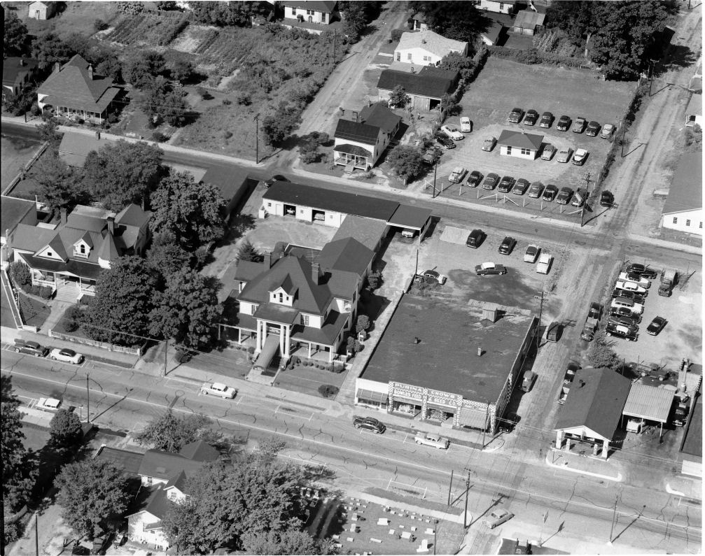
No, this is not a Google Satellite Map. Nothing back to the future here!
It is an aerial photograph taken from an airplane (possibly a helicopter). Other aerial photographs will be posted in the future (Bundy’s Drive-In Theater, historic downtown Monroe, The Great Flood of ’49, and the old overhead bridge).
CLICK HERE to enlarge the picture superimposed with the graphics
or CLICK HERE to enlarge the picture without the graphics.
.
Photographs courtesy of John Gulledge
.
(Some of you may not be aware of the comments under the posts. If so, you’re missing out on the fun. Clicking on the “comments hyperlink” will deliver a pop-up window and allow you to read those comments.)
.
posted by Mystery Blogger @ 11:08 AM
5 comments
![]()
![]()

5 Comments:
No, to the tall building, long ladder, and utility pole theories – but, thanks for the chuckles.
A separate email asked if it was a painting. That same person “was relatively certain” Mary Faith had painted some scenes of downtown Monroe. Hmmm… please let us hear back from you on that, MF.
More pet show pictures in the future – setting the record straight on this particular picture and giving credit where credit is due – Thanks again, John Gulledge.
Some of our classmates may not be aware of this comments window - blogging is a relatively new phenomenon and the print is small.
As a matter of fact, I did do some pen and inks of Monroe (back in the early 1900's). I did these maybe in 1973 when I had moved back to Monroe (from NJ) after my husband died. Geez - I'm trying to remember - think I sold them at Dick Worley's gallery. I wasn't keeping track back then, so I have no idea who bought them. Now I wish I knew.
During that time I helped William Brewer form the Union County Art League or Assoc. Our first juried show was at the then new courthouse. Everyone teased me because I won first place with a charcoal drawing of a nude - in Monroe :-)
We had some shows at the library and one in Charlotte. I sold a drawing of another nude to Marjorie Holmes, who was then a writer for Woman's Day.
FYI, I was more into drawing then and had taken some life drawing classes/workshops in NY and NJ.
When was this photo taken? Looking left at the photo, where did the street go? Did it intersect with Lancaster Ave.? When did the "new" Baptist Church go in at the end of the street? Mystery Blogger, you're driving me nuts! But thanks for the memories, however vague.
Judging from the 1955 Chevrolet parked in front of McEwen, I'd say "mid-fifties" but my memory is also hazy. I remember the colored Easter chicks at the Purina place but I don't remember the service station on the corner.
Recognizing McEwen and Efird Marble across the street is easy - they're still there! But, you're absolutely right - how could a street disappear?
We really need to draw John Gulledge into this thing.
Margaret, that also appears to be a service station on the north side of the Purina Feed & Seed Store. Do you remember that?
Post a Comment
<< Home